
Mt. Rwenzori National Park Mountain Climbing Aafaris & Tours in Uganda

At an elevation of 5,109m above sea level, stands out Mt.Rwenzori National Park.
The Park is located in Western Uganda along the border with the Democratic Republic of Congo, in Kasese district.
The park lies on the east side of the Western Albertine rift valley and covers a total area of about 1,000Km².
Mt.Rwenzori National Park is well known because of its most significant feature, Mt.Rwenzori, which is literally named after the park.
The mountain is the third highest in Africa, having its highest peak Margherita at an elevation of 5,109m. Two of its other peaks are the fourth and fifth highest peaks in Africa, Mount Speke and Mount Stanley respectively.
Mt.Rwenzori is also known as the Mountain of the moon with 70% of its surface above 2,500m altitude. It was formed about 3 million years ago by drifting.
There were several movements on the earth’s crust that resulted into major drifting, resulting into an Uplift of the Underlying Crstalline rocks, forming Africa’s biggest Block mountain, Mt.Rwenzori.
The mountain has 6 massifs separated by deep gorges. They include Mount Luigi di Savoia(4,627m), Mount Gessi (4,715m), Mount Emin (4,798m), Mount Baker (4,843m), Mount Speke (4,890m) and Mount Stanley (5,109m). Read More about Mount Rwenzori National park
Interesting Tourist’s Attractions in Mt. Rwenzori National Park Mountain Climbing Safaris & Tours in Uganda
Vegetation as a Tourist Attraction of Mt.Rwenzori National Park
Apart from the Mountain, the national park happens to have vegetation as the second most tourist attraction, rather than wildlife.
It is characterized by altitudinal vegetation that varies from tropical rainforest, montane forest, tree heathers, Afro-alpine and bamboo.
- At the base of the mountain, there is savannah grassland which covers up to around 1524m altitude.
- Above is the rainforest which covers from around 1,524to 2,286m altitude. Its characterized by lianas, giant ferns, banana plantation
- Beyond is the bamboo forest that goes to about 2,895m altitude. The bamboo grows up to3ft in a single day and reaches about 300ft in a month.
- Above is the health zone that goes up to about 3,657m. It’s characterized by heather trees with mosses and liverwort on the ground. The trees grow up to 40ft tall of more.
- Higher, is the alpine zone that covers up to 4,419m. On the lower section,it has trees such as the groundsel and giant lobelia; and on the upper section it has rocky terrain covered with black lichens and brown mosses.
- Highest above 4,419m to the highest peak Margherita at 5,109m, the mountain is covered by snow and storm swept glaciers.
Birds as a Tourist Attraction in Mt.Rwenzori National Park.
Mt.Rwenzori National park is habitant to about 217 bird species which include 17 endemic Albertine Rift Valley species’ endemic to Mt.Rwenzori National Park.
Some of the bird species include malachite sunbird, long eared own, black eagle, long tailed cuckoo, Long-eared Owl,RwenzoriBatis, Slender-billed Starling, Handsome Francolin, Archers’ Robin-chat, Greenbuls, Lagden’s Bush Shrike, the rare Montane Sooty Boubou, Crimson wings, Apalises, Flycatchers and many more bird species.
Lakes and Rivers as a Tourist Attraction in Mt.Rwenzori National Park
The park has over 20 lakes spread in different points of the park. Some of the easily accessible lakes include Lake Mahoma in the central circuit of the park, in Ruboni; Lake Bukuju is surrounded by steep rock faces that shelter it from the winds in Bukuju valley in the shadows of Mounts Stanley, Speke and Baker.
From a distance, it appears out of the mist with a breathtaking view. You can just hear the little trickle of melt water flowing into the lake from the glacier.
The melted water also flows down by Nyamwamba River into the Nyamwamba valley and Kilembe.
Massifs as a Tourist Attraction in Mt.Rwenzori National Park.
Mt.Stanely ((5,109m)
The mountain is named after a British explorer, Sir Henry Morton Stanley. Stanley took his first glimpse at the area from a distance, but didn’t recognize the mountain.
But in 1888 when he explored the area more, he was able to view the mountain. He was astonished by the magnificent looks of the mountain, covered with snow and clouds at its summits.
He reported the mountain to other Europeans as the Ruwenzori. However, the natives used to call it Rwenjura, a bantu word which means ‘hills of rains’.
The highest summit on Mount Stanley is Margherita Peak.The start point for the hike is at Elena hut. The hike leads up to the first rocks, across the snow and to the ice Stanley Plateau towards Alexandra Peak.
Alexandra peak is the second highest summit on the massif at 4990m. East of the ridge of this peak, is the the standard route for Margheritawhich descends on a steep slope, then climbs the dramatic Margherita Glacier to the Col between Margherita Peak and Alexandra Peak.
From here, you can ascend north to a short but steep rock wall which is leads to the summit. At this point, a rope will be required for the extensively crevassed glacier and the summit rocks. The peak marks the boundary between Uganda and the Democratic Republic of the Congo.
Mt.Baker (4,843m)
It is the third highest massif in the Mt.Rwenzori range and it is named after a British explorer, Sir Samuel Baker.
The massif has four peaks which include Wollaston (4626m), Moore (4623m), Semper (4794m) and Edward (4843m). The hike starts at the beautiful lakes at Kitandara, up towards a field to where the landscape levels out.
You will hike further past several small ponds to a small saddle just west of the ridge, proceeding up to the west of the actual ridgeline. The route takes you up to the summit without having to move through the glacier.
Mt.Speke (4,890m)
It is the second highest massif in the range with a number of summits which include Ensonga (4865m), Johnson (4834m), Vittorio Emanuele (4890m) and others.
The massif is named after a British explorer, John Hanning Speke. Speke believed that the range was the source of River Nile. However, he died before he could prove it.
The trail starts west of the massif from Bujuku in Ruboni. It heads north, up a very steep slope via numerous rocks and vegetation.
You continue up the Southwest ridge to the summit. The great glaciers that used to lie alongthe north side of Mt. Speke melted, leaving only a Glacier on the South; and several small bodies of ice towards the direction of Ensonga Peak.
Ruboni Community as an Attraction of Mt.Rwenzori National Park.
The community is located in Ruboni near the main gate of Mt.Rwenzori national park, Nyakalengija gate. Ruboni community is composed of Bakonzo people, a Bantu tribe, with a total of about 2,000 individuals in the area. Bakonzo people are also known as Bakonjo or Konzo.
They live in hills and mountains at an altitude of about 2,200m. Traditionally, they are agriculturalists, cultivating crops such as beans, sweet potatoes, rice, wheat, cassava, bananas and other crops.
They speak the ‘Rukonjo’ language, which is 77% similar to that of the Nande in the Democratic Republic of Congo.
They were part of the Rwenzururu movement against the Toro Kingdom, a Kingdom in the neighbouring District, Fort Portal.
In 2008,they were recognized as a Tribe in the Rwenzururu Kingdom, Uganda’s first Kingdom to be shared by Two tribes.
The second tribe in the Kingdom is the Amba. During the colonial period, the Bakonzo had been placed under the Toro Kingdom.
The tribe highly emphasizes on the point of Circumcission. You are not a Man Unless u are Circumcised. The Bakonzo, just like the Bagisu of Mbale in Mt.Elgon National park, Eastern Uganda; have circumcision as one of their most entrenched cultural practices.
Unlike the Bagisu who carry out an entertaining ceremony of Circumcision Known as Imbalu, the Bakonzo people do not make any celebrations, neiher do they force any one to get circumcised. There is no mobilization of Circumcision just like the way Bagisu people do.
Before the influence of modernization, Marriage among the Bakonzo was arranged by the parents. when a woman gave birth to a girl child, the fathers with sons came with gifts visited their intended future in-laws with gifts.
It is from these gifts that the girl’s parents decided which family would take their daughter for marriage. The gifts were a symbol of interest in the newly born girl baby, by the different fathers, on behalf for their young sons.
They would also determine the financial status of the boy’s family. When the girl was 7yrs old, she was to be moved to the boys family and start familiarizing with her intended husband.
At the age of 12yrs, she would start having a sexual relationship with the boy. It is believed among the Bakonzo that at that age, she is ready t conceive. If the girl conceived twins (Abahasa), she would get the title of Nyabahasa.
However, she would have to have a onetime sexual intercourse with the boy’s nephew in order to go back to her husbands’ bed.
The event was known as Olhuhasa. A house would be built in the middle of the Boys compound, where the event was to happen. If the olhuhasa didn’t happen, it is believed that the twins would die.
Bakonzo have unique criteria of naming their children. Bakonjo are given names depending on their birth positions in the family.
Baluku/Mumbere, Bwambale, Masereka, Kule, Thembo/Mbusa are names given from the first to fifth sons respectively.
Masiko/Musoki, Biiro, Kabugho, Mbambu, Ithungu, Kyakimo and Nziabake are names given from the first to seventh daughter respectively.
However, today, some of the cultural tracks of the Bakonzo have died out because of Modernization and Education.
Nkokenjeru Ridge and Wanale .
Nkokenjeru Ridge is a distinctive finger of forest extending outwards from the main massif of Mount Elgon. It lies at an elevation of 2,347m and covers a 25km-long tongue of lava that flowed out of the side of the volcano after the cone collapsed to block the main vent.
Nkokenjeru Ridge culminates at the superb Wanale Cliffs which tower above Mbale Town; the seasonal Nabuyonga and Namatyo Waterfalls are located here.
A trail at this western end of the ridge leads you to Khauka Cave where petrified wood can be found.This ridge also offers grounds for those interested in paragliding over the Mbale town.
The Nabuyonga Trail is a 5km loop with birding, fauna and flora. Viewpoints overlook Mbale town, Lakes Kyoga, Bisina and Salisbara, and the rugged mountains in Karamoja region.
On a clear day, you may enjoy vistas of Wagagai peak and even areas of western Kenya. Beware of throwing a stone into the Nabuyonga stream – local folklore claims that if you do so, a thunderstorm will strike before you leave.
Tewei Hill.
Outside the park overlooking Sipi Falls is the hill where, during the 1960s, Chemonges Kingo, King of the Sabiny would meet his subjects.
From the top you can view the three falls, the Karamajong plains and the Wagagai peak. Pian Upe Wildlife Reserve and Matheniko Bokora Wildlife Reserve.
In the plains of Karamoja to the north of Mount Elgon lie Matheniko Bokora Wildlife Reserve and the expansive Pian Upe Wildlife Reserve, the second largest protected area in Uganda, with an area of 2,788km2.
Wildlife found here includes rare species such as the roan antelope, lesser kudu, Bright’s gazelle and ostriches which, in Uganda, are found only here and in Kidepo Valley National Park.
Wildlife is concentrated around the Loporokocho swamp; bird species encountered here include Hartlaub’s Turaco, Eastern Bronze-napped Pigeon, and Lemon Dove, Dusky Turtle Dove, African Hill Babbler, Alpine Chat, Black-throated Wattle-eye, Mountain Yellow Warbler, Thick-billed Honey guide and Grey Cuckoo-Shrike.
Rock paintings found at various sites within the Matheniko Bokora Wildlife Reserve are believed to date back over 3000 years and were created by the Kushite and Nilotic peoples.
Nyero Rock Paintings.
Located just 65km north of Mbale, the Nyero Rock Paintings are the finest of several rock art sites in the region.
Three panels are found within the extensive granite outcrop of Moru Ikara, 10km from Kumi Town and 55km from Mbale on the Soroti road. The most impressive is Panel Two which includes two canoes bearing human figures.
Scenic viewpoints outside the park.
A detour to Bulago off the Mbale-Sipi road reveals a village standing high above a waterfall facing the Simu Valley towards Butandiga ridge.
The route to Kapchorwa beyond Sipi Falls to the north provides a stunning view towards Mount Kadam and the vast plains of Karamoja.
The top of the Sironko Valley in Budadiri, enclosed by the Mudangi Cliffs and the Nkonkonjeru Ridge, provides a picturesque view of the montane forest and caldera peaks. Visitors should also drive to the top of Wanale Cliff for panoramic views over the town of Mbale.
Local people and cultural tours in Mount Elgon National Park.


The various tribal groups that surround the park including the Bagisu, Sabiny and Ndorobos have got impressive cultural traditions, customs and practices.
For example the Imbalu cultural ceremony which is a significant event among the Bagisu where male gender is initiated into manhood.
The locals consider Mount Elgon locally known as Masaba to be the origin of their founding father Masaba.
The traditional Malewa cuisine that is extracted from the Bamboo sots is also thrilling to encounter while on safaris in Uganda.
The Sabiny have got their traditional practice of female genital Mutilation where they will tell you stories about it. The Ndorobo community is famed for its bull fighting experience.
Activities in Mt. Rwenzori National Park Mountain climbing safaris & tours in Uganda

Hiking/Nature Walks as a Tourist Activity of Mt.Rwenzori National Park.
The mountain has a series of trails to hike the mountain.
The easiest Massif to hike is that of Speke because of its steady landscape and penetrable vegetation. Most difficult to hike is that of Stanely and Baker.
They have very steep slopes at about 60°. Usually, it takes a maximum of 7 days to reach the summit of the Mountain.
Hiking trails
The Central Circuit Trail
The trail starts at Mihunga, ascending towards Bujuku valley via Nyabitaba. The trail to the summit takes 4 to 7 days depending on the itinerary chosen.
Itinerary of the Central Circuit Trail.
Day 1: Nyabitaba Hut (2,652m)
Transfer to the Parks headquarters at Nyakalegija to be briefed about the hike ahead. Your language will be weighed to determine the amount to be paid to the porters and also not to carry excess weights.
The trail runs along the western bank of the MubukuRiver; sloping down towards the river through equatorial forest.
At the river, you will cross over using a bridge and from this point which takes about an hour to reach. You will then hike further through ferns and forest; and later, reach the Nyabitaba hut.
Total time: 4-5Hrs.
Day 2: Hiking to John Matte (3414m)
Hiking to John matte marks the beginning of difficult trekking. The hike is the longest and most tiring. It starts with the crossing of Mubuku River at Kurt-shaeffer Bridge.
It’s at this point that the mountain begins to become steep.This part of the trail leads you through bamboo forest, along a ridge that overlooks the Bujuku River valley.
As you climb further, you will be surrounded to the left and right by massive cliffs. As you proceed further, the Moss increases.
After 3 hours of hiking, you will have a stop at Nyamileju Hut for lunch and resting. You will proceed further towards Bujuku River valley with a steadily rising hike and later arriving at John Matte. While at John Matte, you are able to view Mt.Stanaly and Mt.Speke.
Total time: 5-7Hrs
Day 3: Hiking to Bujuku Camp (3,962m)
The trail to Bujuku camp heads west out of John Matte; crossing the Bujuku River and heading out over the Lower Bigo Bog. Bog is a kind of high altitude swamp.
At this point, gumboots and a walking stick are essential requirements to be used because of the presence of Mud at the point.
Upon crossing the Bog, the trail leads to the Bigo hut. At the point, there are interesting plants which include lobelia and Everlasting Flower which is said to have a 40-year flowering cycle.
Past Bigo hut, you will be able to view Lake Bukuju. You will trek east of the lake to reach Bukuju camp.It is not an easy task because even during the dry season, the area in muddy. However, it will be worth the crossing.
Total time: 5hrs
Day 4: Hiking to Elena and Ktandara Hut
While at Bujuku Hut, you can hike Mt.Speke or Stanely Directly. If you intend to proceed up to the Margherita peak, you can then proceed to Elena.
The trail from Bujuku to Elena starts at with a hike to a fairly huge and intimidating ridge.The climb is quite steep for the most part, and vegetation reduces noticeably the higher you climb; until Scott Elliot Pass where the trail consists of moss covered rocky ground with no trees.
The hike up to Scott Elliot pass is one of the hardest of the entire journey. It involves a fairly rapid hike at high altitude.
At the Pass, hikers heading to Elena take the right, while those heading to Kitandara hut take the left and start to descend.
Total time: 3 to 4Hrs.
Day 5: Margherita
An early day trek is required because this will be the longest day of the entire Journey. Assuming all is well, you should head out of the camp by 6:30am and head over the large flat rocks, through deep ravines, climbing up to the snow line.
You will have to carry crampons, ice axes and ropes. At the snow line, the crampons are attached to your hiking boots, and all members of the team roped and attached together.
The trek across the glaciers begins.The ice is extremely hard, rocky solid, and one has to kick hard into the ground with the crampons to gain good stamina.
Crossing the Stanley Plateau takes 30 to 45 minutes, and involves little or no climbing. At the southeast end of the plateau, you descend through a rocky ravine with the crampons still on, to join the Margherita glacier.
However, due to the fact that the summit is exposed, windy and snowy, you will know stay for long. You will then descend to Kitandara Hut.
Total time: 4 to 5Hrs
Day 6: Descending to Guy Yoeman Hut.
Descending from Kitandara Hut, the temperatures are relatively warm. An early morning descending is advised because the distance from Kitandara to Guy yeoman hut is long.
He descent starts over moss-covered rocky ground, the trail descends into the bog covered by Mubuku River valley.
Much of the terrain is crossed by small streams, and the descending can be tough as the trail generally consists of either slipperly rock or muddy bog.
Further descending, you pass under a major cliff where the Duke of Abruzzi camped as he explored the mountain in quest for the peaks.
You will the head further down into the coniferous forests and at last, you will reach Guy Yoeman hut.
Total time: 4 to 6Hrs
Day 7: Descending to Nyakalengija
The last day of trail descends down a steep valley to Kichuchu rock shelter. The trail is quite steep and slippery.
Past Kichuchu, the trail heads into bamboo forest; and continuing to descend, you will cross the Mubuku River at Kicucu Bridge.
The trail then descends through bamboo forest, following the western bank of the Mubuku River valley. The trail then starts to descend down to Nyabitabaridge, ending at Nyabitaba hut.
At this point you will have descended for about 5Hrs. Depending on the conditions, you proceed down to Nyakalengija.
Total Time: 7 to 8Hrs
2. Lake Mahoma Trail
The trail starts in Ruboni at Nyakalengija gate. The trail leads through a rainforest along the Kyambogho ridge where you will be able to see the MubukuRiver and valley.
You will encounter primate species such as the Colobus monkeys, Blue monkeys and sometimes Chimpanzees.
Other wildlife include; forest elephants, bird species in abundance such as the Rwenzorituraco and many others.
The trail will proceed through the bamboo and heather forest; up along a ridge that leads to the Rukenga Valley, you will be astonished by the view of the everlasting flowers and giant lobelias that can grow up to 8m height.The trail ends at Lake Mahoma that is in a valley. You then descend back to Ruboni on the second day.
Rate: US$255
Hiking Requirements
Apart from being physically fit and health wise ok, the following requirements must be obtained in order to hike
- Proper Hiking boots
- Camping Gear such as a tent and sleeping bag.
- Touch
- First Aid Kit and Knife
- A pair of Rain Jacket and Trouser
- A pair of Winter Jacket and Trouser
- Water bottle
- Tourist Backpack
Community Encounters as a Tourist Activity in Mt.Rwenzori National Park.
Ruboni Community Encounter
Ruboni community is located in the foothills of Mt.Rwenzori near the park’s main gate, Nyakalengija gate.
It is boarders by a magnificent rainforest, glacial rivers, banana plantations and other vegetation.The community has approximately 2,000 Bakonzo people.
Enjoy community walks guided by Bakonzo guides as they illustrate to you the daily activities of their community.
Visiting the community will give you an idea of how the locals survive without electricity, gas, technology equipment’s and other modern world requirements. The encounter wil involve the following activities:
- You will be taught by the Bakonzo women how to prepare food using firewood and fresh ingredients from the garden.
- You will meet the local basket weavers and they will teach you how to make items such as baskets, mats other items made out of papyrus.
- An encounter with the community’s traditional healer. Learn about how he treats diseases with just local herbs got from the slopes of Mt.Rwenzori.
- You will be entertained by the locals with a dance accompanied with strong energetic drumming. You could get involved in the drumming and dancing.
The money that you pay to visit the community is funded to various projects in the community such as the Child school sponsoring, tree nursery project, small scale animal husbandry and many more.
| ACTIVITY | RATE US$ |
| Forest Walk | 20 |
| Overnight Hike | 50 |
| Mahoma Trail | 255 |
| Village Walk | 20 |
| Hill Climb Walk | 20 |
Cultural Encounters.

Mount Rwenzori National Park is surrounded by a range of tribal groups particularly the Bakonzo and Bamba who have thrived in this area for centuries past with great traditions and practices that are worth encountering while on safari in Uganda.
Ruboni Community Camp. The village of Ruboni is considered as settlement area of the Bakonzo for over 2,000 years and they have accumulated a lot of heritage which can be explored on Uganda safari.
You can mix up with the community as they undertake their daily routine like animal rearing, cultivation, food preparation along with other activities.
The visit to the traditional healer, blacksmith, craft makers and story tellers will give you a detailed host – guest interaction.
Bulemba-Ihandiro Cultural Trail. The Bulemba – Ihandiro cultural trail takes about 6-7 hours traversing the holy valley and other cultural sites of the Bakonzo.
You are accompanied by the indigenous guide who will take you to the traditional healer’s home called Muhima as he demonstrates his powers to you.
You can also visit the black smith who reveals the value of the Konzo traditional stool. The basket weaving and fire making encounters are incorporated on this trail.
Pass by Kamusonge River whose waters are thought to be sweet and faster in quenching thirst. The Konzo Museum can also be explored on this trail exposing the instruments that were used in the Rwenzururu struggle for succession.
How To Get to Mt. Rwenzori National Park Mountain Climbing Safaris & Tours in Uganda
By road
Kampala – Masaka-Mbarara-Kasese (386km) 5hrs 50min.
The distance from Kampala to Masaka is 131Km and Lasts for approximately 2Hrs.
From Masaka to Mbarara (also known as the land of Milk because of high number of cattle in the area); the distance is approximately 138Km and lasts for about 1Hr 50min.
From Mbarara to Kasese, the distance is about 155Km and lasts approximately 2Hrs. While connecting from Mbarara to Kasese, you will be able to view Queen Elizabeth National Park starting at Kichwamba area.
Kampala –Mityana – Mubende-Fort portal- Kasese(415Km) 6hrs 20min
From Kampala to Mityana, the distance is roughly 72Km and lasts for about 1Hr 10min.
Mityana to Mubende, the distance is about 80Km and lasts for approximately 1Hr. You are able to view physical features such as Lake Wamala, a fresh water lake shared by the two districts.
Mubende to Fortportal, drive distance is about 146Km and lasts for about 1Hr 52min. The route takes you through the magnificent, breath taking Matiri Central Forest Reserve in kabarole district.
From Fort Portal to Kasese, drive time is about 1hr, covering a distance of about 77Km. You will drive around hills and valleys and will be able to view Mt.Rwenzori National Park all the way from Fort Portal to Kaseses. You will bypass one of Uganda’s Cement manufactures, Hima cement, as you approach Kasese Town. You will also cross rivers of Mobuku and Nyamwamba before you are finally in Kasese town.
- By Air
A chattered can be arranged from Entebbe international Airport or Kajjansito :
Mweya Airstrip in mweya (queen Elizabeth National park, and tere after connect to Mt.Rwenzori National Park by road.)
Kasese Airstrip in Kasese town
The flights usually last for about 30minutes.
Accommodations Safari Hotels, Safari Lodges in Mount Elgon National Park Uganda
Equator Snow Lodge – Luxury
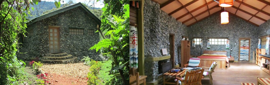 The lodge is located on the foothills of Mt.Rwenzori, near the Nyakalengija gate.
It is under the management of the Geo Lodges. It has a total of 16 beds in en-suite cottages.
The cottages are built out of round like river rocks from river Mobuku. While at the lodge, you are able to view the Mobuku river just below the hill, the glaciers on the mountain and the stunning rainforest. It has facilities such as a restaurant with a fire place and bar.
| ROOM | Rate US$ (Full Board) high season | Rate US$ (Full Board)Low season |
| Double | 330 | 250 |
| Single | 210 | 170 |
| Triple | 430 | 350 |
| Children 5-12yrs sharing with adults. | 50% of adults | 50% of adults |
Ruboni Community Camp – Budget lodge
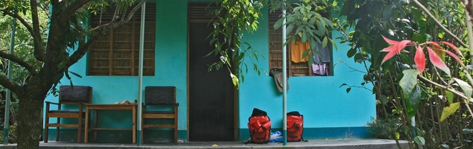 The camp is located on the foothills of Mt.Rwenzori in the village of Ruboni, near the Nyakalengija gate.
Ruboni Community Camp is belongs to the Bakonzo people in the area andThe money that you pay to visit the community is funded to various projects in the community such as the Child school sponsoring, tree nursery project, small scale animal husbandry and many more.
It has 3 en-suite bandas rooms and 6 standard none self-contained rooms. At the camp, you get to have cultural encounters with the locals who will teach you how to cook using firewood; entertain you with dancing; teach you how to weave baskets and many more activities.
| ROOMS | RATE US$ | |
| Bandas | 30 | Bed and Breakfast. |
| Standard | 25 | |
| Camping | 12 | Bed only |
NB: The rate admits to 2 people sharing
Uganda National Parks | Safari Destinations in Uganda
Uganda is a gorgeous place to be and is truly the treasure chest of the African continent. Uganda’s abundance of life in the wild has always inspired peak Safaris in Africa and this is undoubtedly expected to continue in the future. Read More about Uganda Safari Destinations
Queen Elizabeth National Park. Located within the western rift valley floor, Queen Elizabeth National Park was gazetted in 1952 as Kazinga National Park attaining its nomenclature from the 45m long Kazinga channel that bisects the park adjoining Lake George and Lake Edward.
Queen Elizabeth National Park overlooks the highest point in Uganda Rwenzori Mountains with their snowcapped peaks as they were described by Ptolemy in 150AD as the mountains of the moon. Read More about Queen Elizabeth National park
Lake Mburo National Park, The nomenclature of Lake Mburo National Park like most of other African areas cannot go without a legendary connotation.
The legends have it that the two brothers named Kigarama and Mburo settled in the area that is currently occupied by Lake Mburo grazing their long horned cattle across the open savannah plains that thrive up to today.Read More about Lake Mburo National Park
Kidepo National Park, Located in the north eastern part of Uganda, Kidepo Valley National Park covers a geographical landscape of 1,442km2.
It is in the district of Kaboong about 220km from Moroto the biggest town in the sub region and 700km from Kampala the Uganda’s capital city.
Kidepo Valley National Park was established in the year 1962 and it contains 77 species of mammals, 475 bird species of which 60 are endemic to the park on the standards of Uganda. Read More about Kidepo National Park
Mgahinga National Park, which was established in 1991 covers a geographical surface of 33.7km2 making the smallest national Park in Uganda.
Mgahinga National Park is the second habitat that contains the world’s critically endangered mountain gorillas and it is the only national park in Uganda with counts of the rare and endangered golden monkeys which only thrive in the Virunga massif in the whole world. Read More about Mgahinga National Park
Murchison falls National Park, Regarded as Uganda’s largest protected area, Murchison Falls National Park was nowhere until 1952 when 3,840km2 of land in the North West part of Uganda were established as a national Park.
Perched on the northern extreme of the western arm of the great East African rift valley, Murchison Falls National Park is 80km from Masindi town which is the largest town in the sub region and 311km2 from the city of Kampala, the Uganda’s capital. Read More about Murchison falls National Park
Bwindi Impenetrable National Park, Bwindi Impenetrable National Park lies in the south west of Uganda stretching for 321Km2 at an elevation of 1,160 – 2,607 m above sea level.
Bwindi is one of those areas in East Africa with large expanse of Afro montane lowland forest which dates back to the pre-historic era and is known to have survived the last ice age. Read More about Bwindi Impenetrable National Park
Mount Elgon National Park, Spreading to over 1,121km2 of land, Mount Elgon National Park lies with in the eastern side of Uganda close to Kenyan boarder 255km from Kampala which is the country’s capital city.
Mount Elgon which was once the tallest in Africa before it was eroded to being the fourth tallest in East Africa rises up to 4,321m above sea level and is the oldest and largest single standing volcano in East Africa having last erupted approximately 24 million years ago. Read More about Mount Elgon National Park
Mount Rwenzori National Park, had earlier been described by Ptolemy a Greek geographer in 150AD as Lunae Montes translated as the Mountains of the moon and were thought to be the origin of the Nile River which is the longest in world and one of the natural wonders encountered by Uganda safari undertakers. Read More about Mount Rwenzori National Park
Kibale National Park, The park is located in the western part of Uganda sharing the districts of Kabarole and Kamwenge and is 358km surface transfer from Kampala the Uganda’s capital city and 26km from Fort Portal the largest town in the area.
Kibale National Park is entirely forested landscape that stretches to 795km2 of land coverage and it is one of the mature remaining tropical rain forests in Uganda. Read More about Kibale National Park
Semuliki National Park, Spreading to over 220km2 of land surface, Semuliki National Park is located in the west of Uganda in the county of Bwamba, Bundibugyo district.
The park contains a range of species among which include 441 bird species and 53 mammal species. Established in 1993, Semuliki National Park is recognized among the newly established Uganda safari parks in Uganda. Read More about Semuliki National Park
Uganda Wildlife Safari Tours
Uganda has a count of ten (10) national Parks of which four of these are typical savannah with great counts of wild game. Kidepo, Murchison, Queen Elizabeth and Lake Mburo National Parks present memorable wildlife safaris in Uganda.Read More about Uganda Wildlife Safari Tours
3Days Chimpanzee Tracking Safari in Uganda, The Kibale National park also known as the primate capital of the world is located in the west of Uganda and is gifted with 13 primate species. View Itinerary
3Days Uganda Wildlife Safari to Lake Mburo National Park offers you a short wildlife encounter that is closer to Kampala. The impressive savannah landscapes of Lake Mburo. View Itinerary
3Days Uganda Wildlife Safari to Murchison Falls National Park commence and end in Kampala. The safari involves white Rhino tracking in Ziwa Sanctuary, chimpanzee. View Itinerary
3Days Uganda Wildlife Safari to Queen Elizabeth National Park is also the best short wildlife safari that you can have in Uganda. Starting and ending in Kampala. View Itinerary
6Days Uganda safari Adventure, starts and ends in Kampala. The safari takes you through the pearls of western Uganda in including the Queen Elizabeth National Park.View Itinerary
6Days Uganda Wildlife and Chimpanzee Trekking Safari takes you to Murchison Falls and Kibale National Park. It allows you to explore the African Big five. View Itinerary
6Days Uganda Wildlife Safari to Kidepo and Murchison Falls National Parks allows you to explore the big five of land animals in detail. The lions, elephants, Buffaloes. View Itinerary
7Days Uganda Wildlife Safari takes to Queen Elizabeth National Park with its counts of wild life including the elephants, lions, leopard, buffaloes, antelopes, Nile crocodile. View Itinerary
13Days Uganda Classic Wildlife Safari, as its name suggests offers you an opportunity to explore the African game in its wilderness. Starting with the virgin wilderness. View Itinerary
Uganda Gorilla Safaris
Enjoy the world`s surprising Gorilla trekking Uganda African safari destination offering Uganda Gorilla tours / Uganda gorilla safaris – Bwindi Forest National Park and Mgahinga Gorilla Park Uganda.Read More about Uganda Gorilla Safari Tours
3Days Uganda Gorilla Tour to Mgahinga is a Short Uganda Gorilla Tour Trip-Uganda Gorilla Safari Tour to track Gorillas in the Virunga Region-Mt. Mgahinga Gorilla Park.View Itinerary
3Days Bwindi Gorilla Safari in Uganda is a Short Uganda Gorilla Safari-Uganda Gorilla Tour taking you trek gorilla in Bwindi Impenetrable Forest NP. View Itinerary
4Days Uganda Gorilla Safari Bwindi & Wildlife Tour Lake Mburo National Park, takes you Gorilla trekking in Uganda as well as to a Uganda wildlife tour in Lake Mburo park. View Itinerary
6Days Uganda Gorilla Safari & Wildlife Safari in Uganda, is an amazing Uganda Gorilla Tour to Bwindi Forest. Our 6 Days Uganda Gorilla Safari commences. View Itinerary
7Days Uganda Gorilla Safari tour Bwindi, Uganda gorilla safari tour taking you gorilla trekking in Uganda’s Bwindi impenetrable forest. View Itinerary
10Days Uganda Gorilla Safari Holiday & Wildlife Safari in Uganda, A Uganda Gorilla Safari Holiday Tour/Uganda Safari including Gorilla trekking in Bwindi and Wildlife tours in Uganda`s Major Game Parks. View Itinerary
12Days Gorilla Safari Uganda & Wildlife Safari tour in Uganda, is a long Uganda Gorilla Safari to Bwindi Impenetrable Forest Park featuring Wildlife Tour to Uganda wildlife safari parks.View Itinerary
16Days Uganda Gorilla Trekking, Chimpanzees, Wildlife, Culture and Scenic Safari. This is a Long Uganda Safari Tour taking you in all Uganda`s wildlife Safari game parks. View Itinerary
21Days Uganda Gorilla Trekking Safari Tour, Chimpanzee trekking & Wildlife tour is a life time Uganda Safari Africa adventure that is suitable for travelers with long holidays & want to explore as much as they can. View Itinerary
Short Rwanda Gorilla Trekking Tours
1Day Gorilla Tracking Safari in Rwanda -1 Day Rwanda Gorilla Tour Volcanoes Park is an amazing gorilla excursion that you cannot have anywhere else in the region. View Itinerary
2 Days Gorilla Trekking Safari in Rwanda, is a 2 Days Gorilla trekking safari tour in Rwanda & one of the best short gorilla safaris that you can undertake.View Itinerary
3 Days Gorilla Trekking Safari in Rwanda,The 3 Days Short Rwanda Gorilla safari tour starts and ends in Kigali /Kigali Airport but includes Gisozi genocide. View itinerary
4 Days Rwanda Double Gorilla Trekking Safari–Rwanda Gorilla Safari Tour in Volcanoes NP enables one double track mountain Gorillas in Rwanda. View Itinerary
Long Rwanda Gorilla Safari Tours | Long Gorilla trekking Safaris in Rwanda
6 Days Primate Safari in Rwanda – 6 days short Rwanda gorilla safari tour is designed to enable you go Gorilla trekking in Rwanda and have a detailed encounter with the primates of Rwanda.View Itinerary
7 Days Rwanda Gorilla Chimpanzee Birds Safari is a Rwanda Gorilla tracking Safari, Rwanda Chimpanzee trekking Tour & Rwanda Birding Trip. View Itinerary
10 Days Rwanda Gorilla Safari tour Adventure, is a Long Rwanda Gorilla trekking safari tour, and a highlight Rwanda Gorilla Safari, Chimp trekking & a Rwanda wildlife tour. View Itinerary
11 Days Gorilla and Wildlife Safari in Rwanda is one of the comprehensive safaris that can be taken in the destination Rwanda. The safari features a perfect blend of wild game, primates including gorillas and chimpanzees and then Culture. View Itinerary
Rwanda Wildlife Safari Tours | Wildlife Safaris in Rwanda
3 Days Rwanda Wildlife Safari to Akagera National Park. is a perfect short wildlife encounter in the rolling savannah plains of the eastern Rwanda where Akagera National Park is situated overlooking the Tanzanian Plains. View Itinerary
3 Days Rwanda Chimpanzee Safari to Nyungwe Forest National Park, is a thrilling encounter in the pre-historic forest of Nyungwe where counts of habituated Chimpanzees are found.… View Itinerary
5 Days Wildlife and Chimpanzee Safari in Rwanda takes you to the wild game viewing haven of Akagera National Park and the chimpanzee trekking destination of Nyungwe Forest National Park. . View Itinerary
9 Days Rwanda Wildlife Safari is one of those extended safaris in Rwanda that do not feature gorilla trekking. Starting and ending in Kigali, the safari takes you to Akagera National Park which is the only savannah park…View Itinerary
More Info about – Mt. Rwenzori National Park Mountain climbing safaris & tours in Uganda

Mt.Rwenzori National park was declared a UNESCO world heritage site in 1994 because of its magnificent natural beauty, and also recognized as a Ramsar site later in 2008.
However, history of the park dates back in 150CE when a Greek geographer, Claudius Ptolemy, referred to the mountain as a Lunae Montes, a Greek word which means ‘Mountains of the Moon’.
In 1906, an Italian Duke of Abruzzi became the first European to reachMargherita peak. It is at this time that the first detailed Map of the mountain was produced.
For a long time, all the explorers that had moved in the areas near the park didn’t really know that there was a mountain in existence.
The mountain’s summits were covered with snow and clouds. Therefore it was hard for the explorers to identify the mountain.
For instance, in 1876, Henry Morton Stanley took his first glimpse at the area from a distance, but didn’t recognize the mountain.
But in 1888 when he explored the area more, he was able to view the mountain. He was astonished by the magnificent looks of the mountain, covered with snow and clouds at its summits.
On the 7th June 1889, Military commander William Grant Stairs approached the mountain (Mount Emin Pasha) and climbed until 3,254m.
He dint climb further because of the thick vegetation he encountered at the height. Later in 1891, other explorers, Emin Pasha and Dr. Franz Stulman approached the mountain and inspected it.
They confirmed that it was truly a mountain; and in 1900, John EmundSharroke, an Englishbiologist, climbed the mountain until 4,541m altitude.
He became the first European explorer to reach the glaciers of the mountain. When the Duke of the Abruzzi, Prince Luigi Amedeo made quick expeditions of all major snow and Ice Peaks in 1906; he made a mapping of their complex, geography and gave them Italian names.
He had moved along with mountain guides, biologists, surveyors, geologist, photographer and about 150 porters. Later, more explorers flocked the area to visit the mountain.

Over 300 excellent reviews on TripAdvisor
Over 50 excellent reviews on Safaribookings.
Over 50 excellent reviews on Safaribookings.
12+ years of experience.
Best price guarantee.

Cate

Samuel
Speak to a safari specialist to plan your customized Uganda safari and East African tours...
Get top notch safari advice: Call us or schedule a video meeting with our experts.